Alp Weissenstein / Crap Alv (GR)
Site description
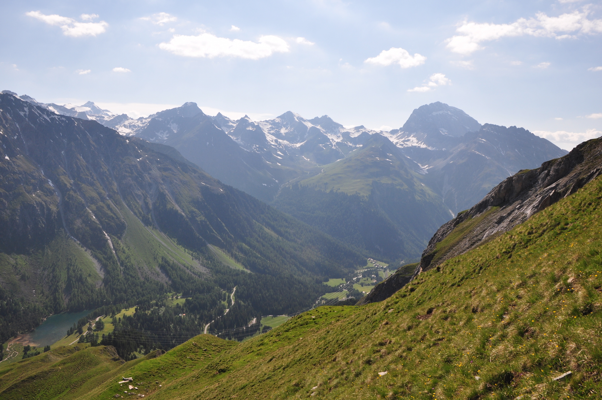
Alp Weissenstein (CH-Aws) is one of the three grasslands within the Swiss FluxNet, but the only one with two names: Crap Alv, as it is called in the local language Romansh.
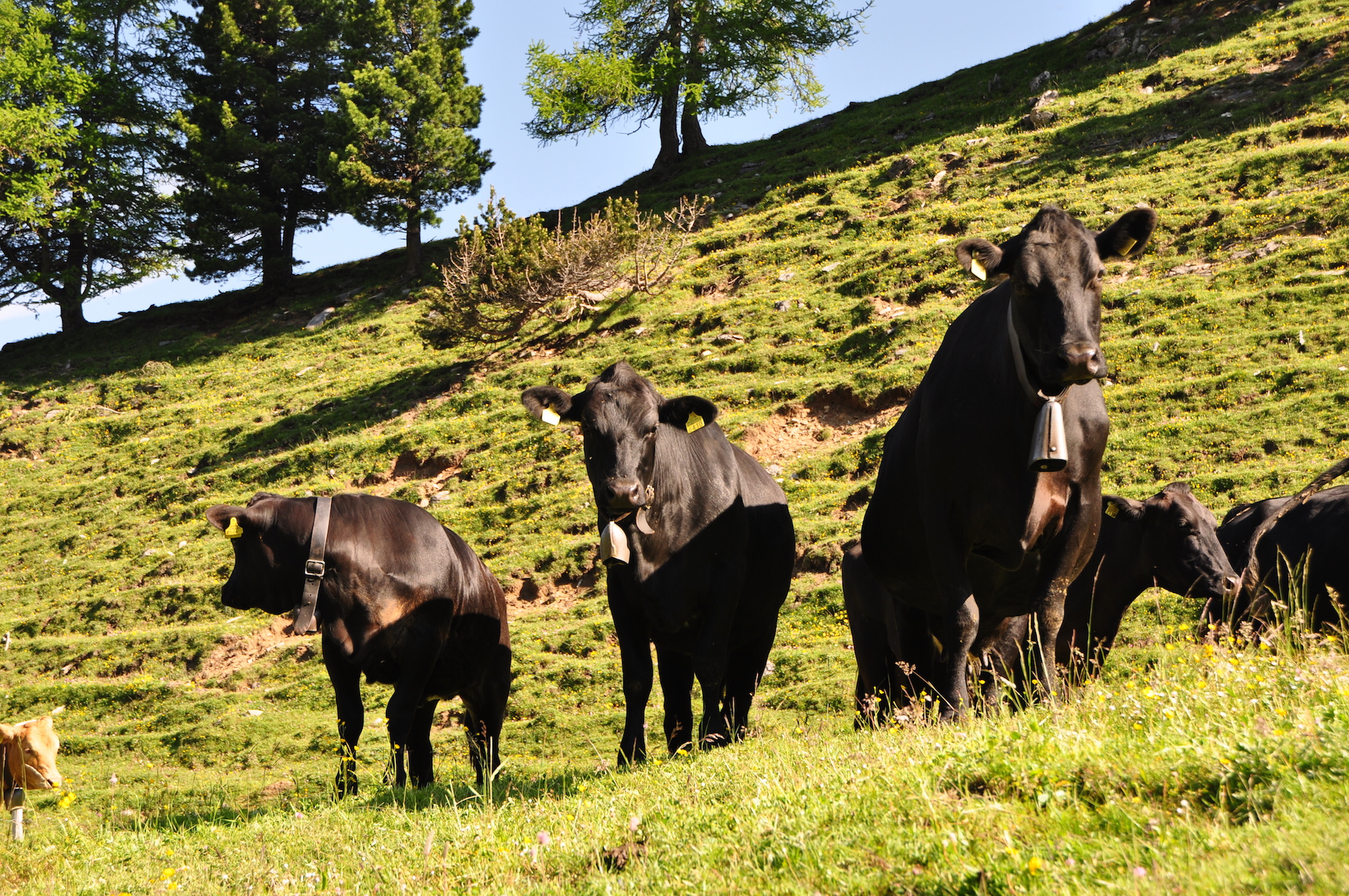
It is a managed (grazed) alpine grassland at 1900–2500 m asl, mainly on calcareous bedrock. The area and the adjacent facilities are part of the external page Agro-Vet Strickhof. For the long-term history of the site, see external page here. Eddy covariance flux measurements were carried out in campaign mode during summer in 2006 to 2014 (tower coordinates: 46°34'59.5" N and 9°47'25.5" E; WGS84 46.583102, 9.790624; at 1978 m asl). Since 2014, measurements are running continuously.
Find out more about the general site info.

Publications
2024
Nelson JA, Walther S, Gans F, Kraft B, Weber U, Novick K, Buchmann N, Migliavacca M, Wohlfahrt G, Šigut L, Ibrom A, Papale D, Göckede M, Duveiller G, Knohl A, Hörtnagl L, Scott RL, Zhang W, Hamdi ZM, Reichstein M, Aranda-Barranco S, Ardö J, Op de Beeck M, Billdesbach D, Bowling D, Bracho R, Brümmer C, Camps-Valls G, Chen S, Cleverly JR, Desai A, Dong G, El-Madany TS, Euskirchen ES, Feigenwinter I, Galvagno M, Gerosa GA, Gielen B, Goslee I, Goslee S, Gough CM, Heinesch B, Ichii K, Jackowicz-Korczynski MA, Klosterhalfen A, Knox S, Kobayashi H, Kohonen KM, Korkiakoski M, Mammarella I, Gharun M, Marzuoli R, Matamala R, Metzger S, Montagnani L, Nicolini G, O'Halloran T, Ourcival JM, Peichl M, Pendall E, Ruiz Reverter B, Roland M, Sabbatini S, Sachs T, Schmidt M, Schwalm CR, Shekhar A, Silberstein R, Silveira ML, Spano D, Tagesson T, Tramontana G, Trotta C, Turco F, Vesala T, Vincke C, Vitale D, Vivoni ER, Wang Y, Woodgate W, Yepez EA, Zhang J, Zona D, Jung M (2024) X-BASE: the first terrestrial carbon and water flux products from an extended data-driven scaling framework, FLUXCOM-X. Biogeosciences 21: 5079-5115, doi: external page 10.5194/bg-21-5079-2024
Nelson JA, Walther S, Gans F, Kraft B, Weber U, Novick K, Buchmann N, Migliavacca M, Wohlfahrt G, Šigut L, Ibrom A, Papale D, Göckede M, Duveiller G, Knohl A, Hörtnagl L, Scott RL, Zhang W, Hamdi ZM, Reichstein M, Aranda-Barranco S, Ardö J, Op de Beeck M, Billdesbach D, Bowling D, Bracho R, Brümmer C, Camps-Valls G, Chen S, Cleverly JR, Desai A, Dong G, El-Madany TS, Euskirchen ES, Feigenwinter I, Galvagno M, Gerosa GA, Gielen B, Goslee I, Goslee S, Gough CM, Heinesch B, Ichii K, Jackowicz-Korczynski MA, Klosterhalfen A, Knox S, Kobayashi H, Kohonen KM, Korkiakoski M, Mammarella I, Gharun M, Marzuoli R, Matamala R, Metzger S, Montagnani L, Nicolini G, O'Halloran T, Ourcival JM, Peichl M, Pendall E, Ruiz Reverter B, Roland M, Sabbatini S, Sachs T, Schmidt M, Schwalm CR, Shekhar A, Silberstein R, Silveira ML, Spano D, Tagesson T, Tramontana G, Trotta C, Turco F, Vesala T, Vincke C, Vitale D, Vivoni ER, Wang Y, Woodgate W, Yepez EA, Zhang J, Zona D, Jung M (2024) X-BASE: the first terrestrial carbon and water flux products from an extended data-driven scaling framework, FLUXCOM-X. EGUsphere [preprint], doi: external page 10.5194/egusphere-2024-165
Osterwalder S, Schibler R, Hüglin C, Schwarzenbach B, Stupple G, MacSween K,Bishop K, Alewell C, Buchmann N (2024) Spatial and seasonal dynamics of gaseous elemental mercury concentrations over Switzerland observed by a passive air sampler network. Environmental Science: Atmospheres 4: 848-860, doi: external page 10.1039/D4EA00052H
2023
Abdalla M, Feigenwinter I, Richards M, Vetter SH, Wohlfahrt G, Skiba U, Pintér K, Nagy Z, Hejduk S, Buchmann N, Newell Price P, Smith P (2023) Evaluation of the ECOSSE model for estimating soil respiration from eight European permanent grassland sites. Agronomy 13: 1734, doi: external page 10.3390/agronomy13071734
Li Y, Eugster W, Riedl A, Lehmann MM, Aemisegger F, Buchmann N (2023) Dew benefits on alpine grasslands are cancelled out by combined heatwave and drought stress. Frontiers in Plant Science 14: 1136037, doi: external page 10.3389/fpls.2023.1136037
Tang ACI, Flechard CR, Arriga N, Papale D, Stoy PC, Buchmann N, Cuntz M, Douros J, Fares S, Knohl A, Šigut L, Simioni G, Timmermans R, Grünwald T, Ibrom A, Loubet B, Mammarella I, Belelli Marchesini L, Nilsson M, Peichl M, Rebmann C, Schmidt M, Bernhofer C, Berveiller D, Cremonese E, El-Madany TS, Gharun M, Gianelle D, Hörtnagl L, Roland M, Varlagin A, Fu Z, Heinesch B, Janssens I, Kowalska N, Dušek J, Gerosa G, Mölder M, Tuittila E-S, Loustau D (2023) Detection and attribution of an anomaly in terrestrial photosynthesis in Europe during the COVID-19 lockdown. Science of the Total Environment 166149, doi: external page 10.1016/j.scitotenv.2023.166149
Xie M, Ma X, Wang Y, Li C, Shi H, Yuan X, Hellwich O, Chen C, Zhang W, Zhang C, Ling Q, Gao R, Zhang Y, Ochege FU, Frankl A, De Maeyer P, Buchmann N, Feigenwinter I, Olesen JE, Juszczak R, Jacotot A, Korrensalo A, Pitacco A, Varlagin A, Shekhar A, Lohila A, De Ligne A, Carrara A, Brut A, Kruijt B, Loubet B, Heinesch B, Chojnicki B, Helfter C, Vincke C, Shao C, Bernhofer C, Brümmer C, Wille C, Tuittila ES, Nemitz E, Meggio F, Dong G, Lanigan GJ, Niedrist G, Wohlfahrt G, Zhou G, Goded I, Gruenwald T, Olejnik J, Jansen J, Neirynck J, Tuovinen JP, Zhang J, Klumpp K, Pilegaard K, Šigut L, Klemedtsson L, Tezza L, Hörtnagl L, Urbaniak M, Roland M, Schmidt M, Sutton MA, Hehn M, Saunders M, Mauder M, Aurela M, Korkiakoski M, Du M, Vendrame N, Kowalska N, Leahy PG, Alekseychik P, Shi P, Weslien P, Chen S, Fares S, Friborg T, Tallec T, Kato T, Sachs T, Maximov T, Morra di Cella U, Moderow U, Li Y, He Y, Kosugi Y, Luo G (2023) Monitoring of carbon-water fluxes at Eurasian meteorological stations using random forest and remote sensing. Scientific Data 10: 587, doi: external page 10.1038/s41597-023-02473-9
2022
Fu Z, Ciais P, Makowski D, Bastos A, Stoy P,C, Ibrom A, Knohl A, Migliavacca M, Cuntz M, Šigut L, Peichl M, Loustau D, El-Madany TS, Buchmann N, Gharun M, Janssens I, Markwitz C, Grünwald T, Rebmann C, Mölder M, Varlagin A, Mammarella I, Kolari P, Bernhofer C, Heliasz M, Vincke C, Pitacco A, Cremonese E, Foltýnová L, Wigneron J-P (2022) Uncovering the critical soil moisture thresholds of plant water stress for European ecosystems. Global Change Biology 28: 2111-2123, doi: external page 10.1111/gcb.16050
2020
Gharun M, Hörtnagl L, Paul-Limoges E, Ghiasi S, Feigenwinter I, Burri S, Marquardt K, Etzold S, Zweifel R, Eugster W, Buchmann N (2020) Physiological response of Swiss ecosystems to 2018 drought across plant types and elevation. Philosophical Transactions of the Royal Society B 375: 20190521, doi: external page 10.1098/rstb.2019.0521
Graf A, Klosterhalfen A, Arriga N, Bernhofer C, Bogena H, Bornet F, Brüggemann N, Brümmer C, Buchmann N, Chi J, Chipeaux C, Cremonese E, Cuntz M, Dušek J, El-Madany TS, Fares S, Fischer M, Foltynova L, Gielen B, Gottschalk P, Gharun M, Ghiasi S, Grünwald T, Heinemann G, Heinesch B, Heliasz M, Holst J, Hörtnagl L, Ibrom A, Ingwersen J, Jurasinski G, Klatt J, Knohl A, Koebsch F, Konopka J, Korkiakoski M, Kowalska N, Kremer P, Kruijt B, Lafont S, Léonard J, De Ligne A, Longdoz B, Loustau D, Magliulo V, Mammarella I, Manca G, Mauder M, Migliavacca M, Mölder M, Ney P, Nilsson M, Neirynck J, Paul-Limoges E, Peichl M, Pitacco A, Poyda A, Rebmann C, Roland M, Sachs T, Schmidt M, Siebicke L, Schrader F, Šigut L, Tuittila ES, Varlagin A, Vendrame N, Vincke C, Völksch I, Wille C, Weber S, Wizemann HD, Zeeman M, Vereecken H (2020) Altered energy partitioning across terrestrial ecosystems in the European drought year 2018. Philosophical Transactions of the Royal Society B 375: 20190524, doi: external page 10.1098/rstb.2019.0524
Nelson JA, Pérez-Priego O, Zhou S, Poyatos R, Zhang Y, Blanken PD, Gimeno TE, Wohlfahrt G, Desai AR, Gioli B, Limousin JM, Bonal D, Paul-Limoges E, Scott RL, Varlagin A, Fuchs K, Montagnani L, Wolf S, Delpierre N, Berveiller D, Gharun M, Marchesini LB, Gianelle D, Šigut L, Mammarella I, Siebicke L, Black TA, Knohl A, Hörtnagl L, Magliulo V, Carvalhais N, Migliavacca M, Reichstein M, Jung M (2020) Ecosystem transpiration and evaporation: insights from three water flux partitioning methods across FLUXNET sites. Global Change Biology 26: 6916-6930, doi: external page 10.1111/gcb.15314
Pastorello GZ, … Buchmann N, … Eugster W, … Feigenwinter I, … Gharun M, … Hörtnagl L, …, Maier R, … Merbold L, …, Paul-Limoges E, … in total 286 coauthors (2020) The FLUXNET2015 dataset and the ONEFlux processing pipeline for eddy covariance data. Scientific Data 7: 225, doi: external page 10.1038/s41597-020-0534-3
2019
Gilgen AK, Klaus VH, Lüscher A, Buchmann N (2019) ‘From research – for practice’: translating research findings for practical application. In: Huguenin-Elie O, Studer B, Kolliker R, Reheul D, Probo M, Barre P, Feuerstein U, Roldan-Ruiz I, Mariotte P, Hopkins A (Eds.) Improving sown grasslands through breeding and management. p. 536
2017
Eugster E, Emmel C, Wolf S, Buchmann N, McFadden JP, Whiteman CD (2017) Effects of vernal equinox solar eclipse on temperatures and wind directions in Switzerland. Atmospheric Chemistry and Physics 17: 14887-14904, doi: external page 10.5194/acp-17-14887-2017
Wilcox K R, Shi Z, Gherardi L A, Lemoine N P, Koerner S E, Hoover D L, Bork E, Byrne K N, Cahill Jr. J, Collins S L, Gilgen AK, Holub P, Jiang L, Knapp A K, LeCain D, Liang J, Garcia-Palacios P, Peñuelas J, Pockmann W T, Smith M D, Sun S, White S R, Yadjian L, Zhu K, Luo Y (2017) Asymmetric responses of primary productivity to precipitation extremes: A synthesis of grassland precipitation manipulation experiments. Global Change Biology 23: 4376-4385, doi: external page 10.1111/gcb.13706
2015
Prechsl UE, Burri S, Gilgen AK, Kahmen A, Buchmann N (2015) No shift to deeper water uptake depth in response to summer drought of two lowland and sub-alpine C3 grasslands in Switzerland. Oecologia 177: 97-111
2014
Prechsl UE, Gilgen AK, Kahmen A, Buchmann N (2014) Reliability and quality of water isotope data collected with a low budget precipitation collector. Rapid Communications in Mass Spectrometry 28: 879-885
2013
Kohler M, Leiber F, Willems H, Merbold L, Liesegang A (2013) Influence of altitude on vitamin D and bone metabolism of lactating sheep and goats Journal of Animal Science 91: 5259-5268, doi: external page 10.2527/jas.2013-6702
Imer D, Merbold L, Eugster W, Buchmann N (2013) Temporal and spatial variations of CO2, CH4 and N2O fluxes at three differently managed grasslands. Biogeosciences 10: 5931-5945, doi: external page 10.5194/bg-10-5931-2013
Finger R, Gilgen AK, Prechsl U, Buchmann N (2013) An economic assessment of drought effects on three grassland systems in Switzerland. Regional Environmental Change 2: 365-374
2011
Hartmann AA, Buchmann N, Niklaus PA (2011) A study of soil methane sink regulation in two grasslands exposed to drought and N fertilization. Plant and Soil 342: 265-275
Stiehl-Braun PA, Hartmann AA, Kandeler E, Buchmann N, Niklaus PA (2011) Interactive effects of drought and N fertilisation on the spatial distribution of methane assimilation in grassland soils. Global Change Biology 17: 2629-2639
2010
Zeeman MJ, Hiller R, Gilgen AK, Michna P, Plüss P, Buchmann N, Eugster W (2010) Management, not climate, controls net CO2 fluxes and carbon budgets of three grasslands along an elevational gradient in Switzerland. Agricultural and Forest Meteorology 150: 519-530
2009
Gilgen AK, Buchmann N (2009) Response of temperate grasslands at different altitudes to simulated summer drought differed but scaled with annual precipitation. Biogeosciences 6: 2525-2539
2008
Gilgen AK, Buchmann N (2008) Effects of summer drought on temperate grassland performance. Grassland Science in Europe 13: 913-915
Hiller R, Zeeman MJ, Eugster W (2008) Eddy covariance flux measurements in the complex terrain of an Alpine valley in Switzerland. Boundary-Layer Meteorology 129: 449-467
Student theses
2018
Patrick Krähenbühl (BSc Agrarwissenschaften), ETH Zurich. CO2 fluxes during the snowmelt period on the subalpine grassland at Crap Alv
2011
Christine Steinlin (MSc Env. Sciences), ETH Zurich. Winter fluxes of CO2, CH4 and N2O on a subalpine grassland
2010
Gwendolin Bitter (MSc Atmospheric and Climate Sciences), ETH Zürich. Microclimate of alpine grasslands under experimental drought conditions
2007
Samuel Schmid (Agrar. Ing.), ETH Zurich. Funktionelle und pflanzensoziologische Charakterisierung der alpin-subnivalen Vegetation im Gebiet der ETH-Forschungsstation Alp Weissenstein am Albulapass (GR, Schweiz)